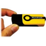
 This sort of follows on from the review I did a few days ago of the Gisteq PhotoTrackr. I was not overly enamored with the software that came in the box with the PhotoTrackr but it did allow you to export the GPS track to a .gpx file and that meant you can upload it to other software. With the introduction of Aperture 3.0, Apple added compatibility with geotagging to the popular photographic organizational tool. The new “places” tool in Aperture 3 lets you sort and view your photos by location, and also lets you geotag your photos either by uploading a .gpx file from a third party tracking device or by syncing with information in your iPhone photos.
geotagging
Gisteq PhotoTrackr review
 I’ve had a mild curiosity in geotagging for a while. Years from now, i’ve always thought that it wold be very cool to know exactly where some of my photos were taken. Especially my backcountry skiing photos where they are not necessarily taken near any recognizable landmarks. As I travel more and more to other parts of the world too, it would be nice to look back at that in the future and see exactly where I was.
For Canon shooters you instantly run into a problem though. So far Canon has refused to add geotagging to any of their cameras and they have also refused to add the ability for third-party developers to come up with their own solution. Nikon users have it pretty easy by comparison with their G-P1. It connects directly to the camera and writes the GPS location of the photo straight into the metadata. If you shoot Canon though you are going to need to do a little extra work and I was intrigued to find out how much effort it would be to integrate this into my current workflow, especially now that Apple have integrated geotagging into Aperture 3.0. A bit of research led me to the Gisteq PhotoTrackr mini.
